 Software > Data analysis > SCULPT - Scientific Construction of Satellite Data Products Toolkit


Key highlights
- Automated Data Processing – Seamless generation of analytics-ready data products.
- Zero Infrastructure Investment – No additional resources required for data processing.
- Custom Software Solutions – Tailored to integrate seamlessly with your satellites.
- In-Flight & Ground Calibration – Ensuring radiometric and geometric accuracy.
- Optimized Processing Efficiency – Parallel processing for reduced turnaround time.
- User-Centric Experience – Intuitive interface for effortless data access.
- Comprehensive Documentation – Step-by-step guidelines for transparency and ease of use.
- Regular Software Updates – Ensuring optimal performance and security.
- Expert Consultation – Guidance from mission design to payload calibration.
- 24/7 Technical Support – Continuous monitoring and anomaly resolution.
- Advanced Image Enhancement – Improved data clarity and precision.
- Data Management & Access – Tasking APIs, archival systems, and secure repositories.
- Quality, Cost-Effective, and Timely Delivery – Meeting the highest industry standards.
Applications
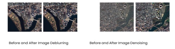
- Image Deblurring
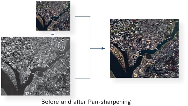
- Pan Sharpening
- Flat-field and Radiance Correction
- Precision & Relief Correction
- Standardized Data Formatting
- Image Denoising
- Super Resolution
- Exposure Fusion
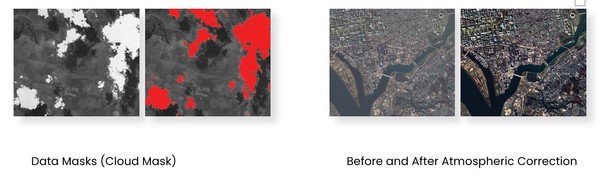
- Data Masks
- Data Dissemination Platform
- Image Mosaicking/ Optical Butting Correction
- Atmospheric Correction
- Geometric Tagging & Resampling
- Band-to-Band Registration
- Ground Operations Software
Key features
SCULPT (Scientific Construction of Satellite Data Products Toolkit). It is designed for clients seeking to leverage APRIL's unparalleled expertise, SCULPT transforms raw satellite packets into actionable, analytics-ready data products. This service provides automated data processing and archiving, streamlining operations for our valued customers. Our team comprises seasoned specialists in image and signal processing, Software systems, boasting extensive experience spanning decades in generating data products from the most challenging earth observation payloads.
Payload Served:
- Panchromatic (Sub-Meter to Coarse Resolution)
- Multi-spectral Imagery
- Hyper-spectral Imagery
- Infrared Imagery
- Synthetic Aperture Radar Imagery
The following table outlines the various levels of data processing:
- Level 0
Unprocessed, uncalibrated, and unrectified raw data acquired directly from the satellite payload. - Level 1
Radiance product incorporating radiometric and geometric corrections - Level 2
Reflectance product derived from Level 1 data, with atmospheric corrections and reflectance corrections to improve data reliability - Level 3 (Higher Level)
Pan-sharpened imagery, integrating high-resolution panchromatic data with multispectral bands to enhance spatial detail, improving feature extraction and analysis
Disclaimer: satsearch is not responsible for any mistakes on this page, although we do our best to ensure correctness. Please report any mistakes to us.
Last updated: 2026-01-13

SCULPT - Scientific Construction of Satellite Data Products Toolkit
Export